Click to read more...
Property Overview
The Pot Rustler gold mining property is a 120-acre lode mining site located in the high mountains outside of Sheridan, Montana. The region is dotted with more than 100 gold mines that have produced gold, silver and copper. Many of the mines, such as the Pot Rustler, have been operational within the past few years, albeit on a small scale.
The Pot Rustler has also been known as the Pedro mine historically. The mine was operated in 1960-1980 under the name “Pot Rustler” making it the most relevant naming.
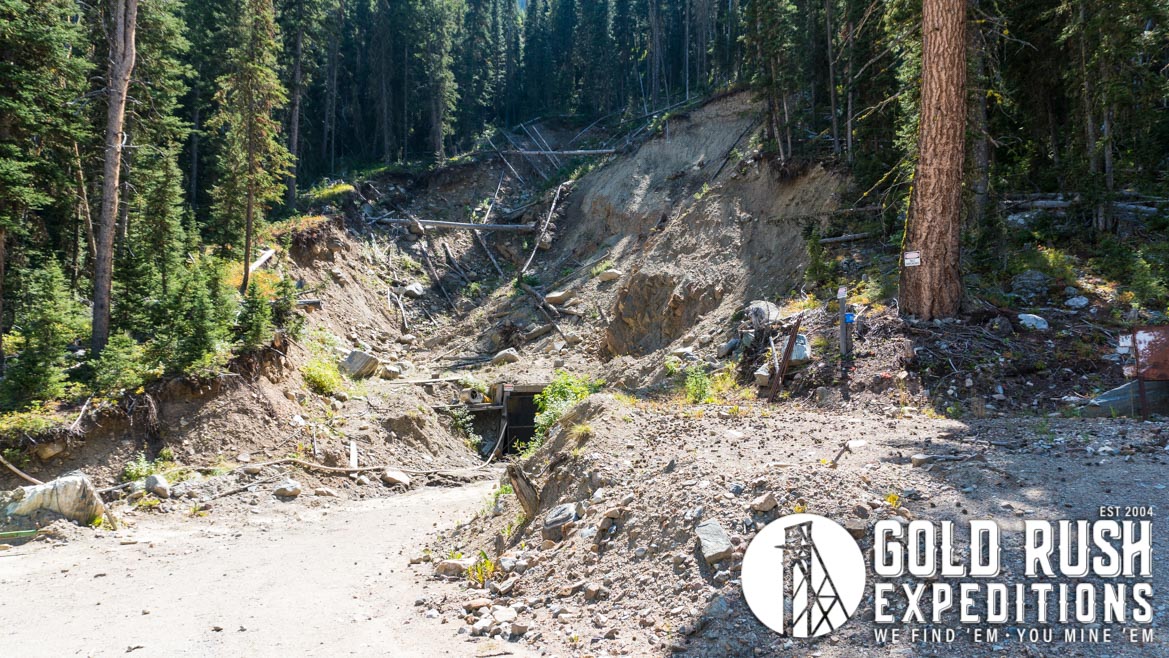
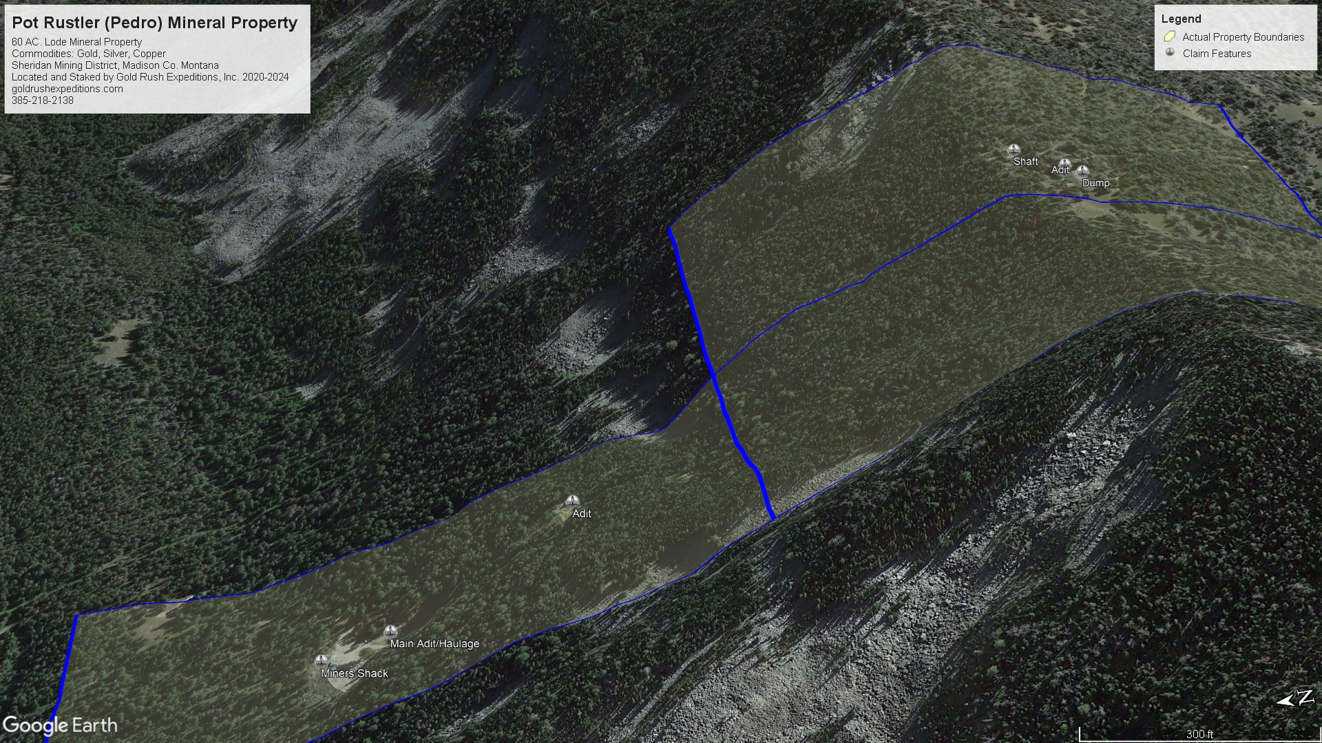
The majority of the Pot Rustler property is located on the north facing slope of a steep mountainside. The mine is a series of cuts starting just above the creek. The lower and middle portals are adit cuts consisting of 400-600’ of workings estimated. There is some slough and collapse in both of these portals. They appear to be connected sub-surface, either by raises or a large open stope. Vertically the lower portal is 290’ below the middle portal. Equating to at least 290’ of workings between the two portals. There are at least two ore bins inside the lower level and the muck from the lower portal does not seem consistent with the material being processed. This indicating there was another source of the material, and the lower portal was primarily used for haulage.
The upper portal is largely collapsed and inaccessible at current. It is located 261 vertical feet above the middle portal. This appears to have been a decline shaft from onsite surveyor assessments. The vein was chased through the mountain and there is a shaft on the south side of the ridge. This shaft is also collapsed and is reported to be a largely vertical shaft of unreported depth. Material at the dump of the shaft is reportedly similar to the shipping ore from the workings on the north face of the mountain.
There is excellent access to the lower portal via a gated and maintained dirt road. There is a small stream crossing that should present no significant issues to any high clearance vehicles.
The mine is reported to have produced gold on a consistent basis from the time of location, reliably documented to be 1932-1933. While there is sparse history on the site, it is known to have operated until 2000-2001. The mine was permitted again and operated from 2011-2018. There are no known records of production.
Assays were taken at the site, from the dumps and targeted locations inside the lower portal. Dump material averaged 1/3 oz. AU per ton. Vein material from inside the workings averaged 1.4 oz AU per ton. Silver and copper were also present in small quantities.
In summary, the Pot Rustler property has an excellent basis and history of production and supporting the miners operating the site. All work has been done on a small scale but appears to have been lucrative enough to build homes and sheds on site. The workings will need some rehabilitation and stabilization to be safe for underground operations.
The ideal operation would be a 4–6-man team who could clear the workings and define and map the existing veins and ore bodies. With this mapping in place, the veins could be exploited with for targeted returns.
Gold Rush Expeditions, Inc. does offer mining consultation services and assistance with permits for a small fee.
Training courses for underground work and exploration can be found here: https://stayoutstayalive.com/training/
The Pot Rustler gold mining property is a 120-acre lode mining site located in the high mountains outside of Sheridan, Montana. The region is dotted with more than 100 gold mines that have produced gold, silver and copper. Many of the mines, such as the Pot Rustler, have been operational within the past few years, albeit on a small scale.
The Pot Rustler has also been known as the Pedro mine historically. The mine was operated in 1960-1980 under the name “Pot Rustler” making it the most relevant naming.
The majority of the Pot Rustler property is located on the north facing slope of a steep mountainside. The mine is a series of cuts starting just above the creek. The lower and middle portals are adit cuts consisting of 400-600’ of workings estimated. There is some slough and collapse in both of these portals. They appear to be connected sub-surface, either by raises or a large open stope. Vertically the lower portal is 290’ below the middle portal. Equating to at least 290’ of workings between the two portals. There are at least two ore bins inside the lower level and the muck from the lower portal does not seem consistent with the material being processed. This indicating there was another source of the material, and the lower portal was primarily used for haulage.
The upper portal is largely collapsed and inaccessible at current. It is located 261 vertical feet above the middle portal. This appears to have been a decline shaft from onsite surveyor assessments. The vein was chased through the mountain and there is a shaft on the south side of the ridge. This shaft is also collapsed and is reported to be a largely vertical shaft of unreported depth. Material at the dump of the shaft is reportedly similar to the shipping ore from the workings on the north face of the mountain.
There is excellent access to the lower portal via a gated and maintained dirt road. There is a small stream crossing that should present no significant issues to any high clearance vehicles.
The mine is reported to have produced gold on a consistent basis from the time of location, reliably documented to be 1932-1933. While there is sparse history on the site, it is known to have operated until 2000-2001. The mine was permitted again and operated from 2011-2018. There are no known records of production.
Assays were taken at the site, from the dumps and targeted locations inside the lower portal. Dump material averaged 1/3 oz. AU per ton. Vein material from inside the workings averaged 1.4 oz AU per ton. Silver and copper were also present in small quantities.
In summary, the Pot Rustler property has an excellent basis and history of production and supporting the miners operating the site. All work has been done on a small scale but appears to have been lucrative enough to build homes and sheds on site. The workings will need some rehabilitation and stabilization to be safe for underground operations.
The ideal operation would be a 4–6-man team who could clear the workings and define and map the existing veins and ore bodies. With this mapping in place, the veins could be exploited with for targeted returns.
Gold Rush Expeditions, Inc. does offer mining consultation services and assistance with permits for a small fee.
Training courses for underground work and exploration can be found here: https://stayoutstayalive.com.training/
Acres
Commodities
Type
60
Gold, Silver, Copper, Lead
Lode
Underground Dev
Surface Dump
Tailings
3,000 feet
380,998 tons
N/A
Access
Features
High clearance 4WD
N/A
Gold Reserves
Silver Reserves
Copper Reserves
Platinum Reserves
Tungsten Reserves
Molybdenum Reserves
128,009 oz
150,612 oz
Undefined
N/A
N/A
N/A
(385) 218-2138
or use our contact form below