Under Contract
Click to read more...
Property Overview
The Culverwell Mineral property is a 20-acre lode property. The property contains a documented, producing gold and silver mine. The Culverwell Mine is located in Lincoln County, Nevada. The mine has limited documentation of production but shows average values of 1.44 oz/T AU and 2.31 oz/T AG. The mine was located by Mr. Charles Culverwell and Mr. William Culverwell in 1899. The mine was re-located by two miners in the resurgence of 1932 and documented production of 5 tons of ore containing 7.2 ounces of gold and 11.5 ounces of Silver.
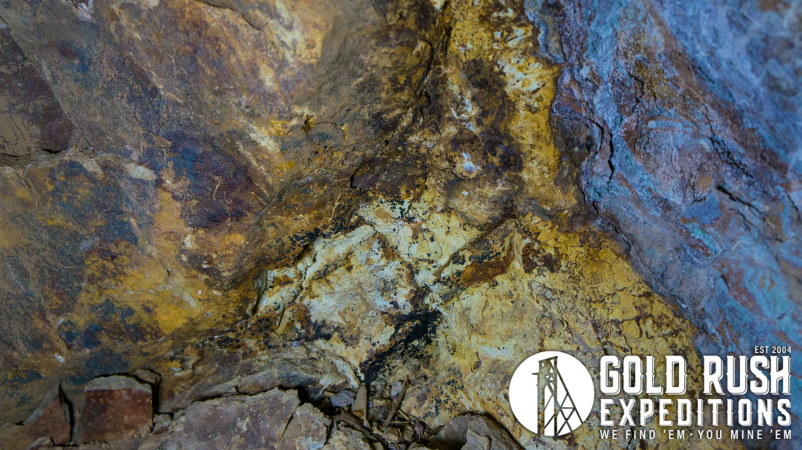
The mine is noted for veins of quartz containing free-milling, or native, gold deposits. Silver, Lead and Zinc are also noted in assays, but are not noted for production value.
There are no blocked or inferred reserves despite the extensive underground development. The original locators of the mine are William and Charles Culverwell, brothers, who founded the town of Culverwell, which would later become Caliente.
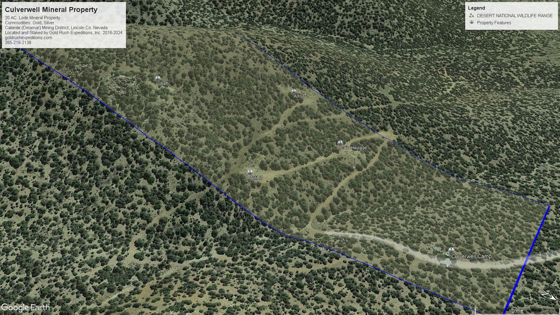
The mine has at least three portals which intersect the veins as noted in geological reports. The workings are reported to interconnect via winzes and raises. The two upper portals have collapsed or been backfilled and are not accessible as of 2018. The primary Culverwell Adit is in good condition and accessible. It is secured by a large iron gate and reinforced with timber cribbing. The mine itself is cut in competent rock and is stable with no slough or collapses noted inside.
Below the mines and part of the Culverwell property is the Culverwell Camp or History Repeats camp as it has also been known. The camp is quite extensive and a testament to the workings of the mine. A large, 3-bedroom house has been laid out with a kitchen, dining room and an upper-level workshop. The majority of the cabin has been utilized for processing of the gold and there are various mining implements, tables, and separation vats in the house.
There is a carport outside the house with concrete foundations and room for at least 3 full size vehicles. In addition, there is a large cistern (assumed 5000 gallon) attached to the house, fully concreted and above ground. Other indications of habitation at the site include chicken coops, outhouses, and various outdoor tubs with exposed plumbing. There is an inscription on the concrete near the cistern which reads “History Repeats”.
Waste Dumps at the mine were sampled and assayed. High grade samples contained quartz, pyrites, native gold, some silver, and iron.
The accessible workings in the mine consist of a haulage tunnel with some short offshoots and a stoped room where a gold ore body appears to have been stopped at a dike. The ore body continues vertically up and down and is chased by a winze. There is a small headframe over the winze of approximately 30’. At the bottom of this winze, there is a drift cutting back on the same ore deposit as above. The lower level was not mapped or examined but it said to intersect with the workings of the upper two adits through a series of raises and other drifts. This information is unverified.
In addition to the lower levels, also noted was a potential raise near the headframe, the passageway was extremely narrow and was likely an ore chute at one time, however, it is possible to attempt access to upper levels through this raise.
The mine is noted for production of “wire gold” in iron-stained quartz. Surveyors did not witness any wire gold, however, surveyors reported multiple instances of visible native gold in quartz in the short offshoots of the haulage tunnel and some high-grade gold samples were removed from the main working room/stope.
Gold Rush Expeditions, Inc. does offer mining consultation services and assistance with permits for a small fee.
Training courses for underground work and exploration can be found here: https://stayoutstayalive.com/training/
The Culverwell Mineral property is a 20-acre lode property. The property contains a documented, producing gold and silver mine. The Culverwell Mine is located in Lincoln County, Nevada. The mine has limited documentation of production but shows average values of 1.44 oz/T AU and 2.31 oz/T AG. The mine was located by Mr. Charles Culverwell and Mr. William Culverwell in 1899. The mine was re-located by two miners in the resurgence of 1932 and documented production of 5 tons of ore containing 7.2 ounces of gold and 11.5 ounces of Silver.
The mine is noted for veins of quartz containing free-milling, or native, gold deposits. Silver, Lead and Zinc are also noted in assays, but are not noted for production value.
There are no blocked or inferred reserves despite the extensive underground development. The original locators of the mine are William and Charles Culverwell, brothers, who founded the town of Culverwell, which would later become Caliente.
The mine has at least three portals which intersect the veins as noted in geological reports. The workings are reported to interconnect via winzes and raises. The two upper portals have collapsed or been backfilled and are not accessible as of 2018. The primary Culverwell Adit is in good condition and accessible. It is secured by a large iron gate and reinforced with timber cribbing. The mine itself is cut in competent rock and is stable with no slough or collapses noted inside.
Below the mines and part of the Culverwell property is the Culverwell Camp or History Repeats camp as it has also been known. The camp is quite extensive and a testament to the workings of the mine. A large, 3-bedroom house has been laid out with a kitchen, dining room and an upper-level workshop. The majority of the cabin has been utilized for processing of the gold and there are various mining implements, tables, and separation vats in the house.
There is a carport outside the house with concrete foundations and room for at least 3 full size vehicles. In addition, there is a large cistern (assumed 5000 gallon) attached to the house, fully concreted and above ground. Other indications of habitation at the site include chicken coops, outhouses, and various outdoor tubs with exposed plumbing. There is an inscription on the concrete near the cistern which reads “History Repeats”.
Waste Dumps at the mine were sampled and assayed. High grade samples contained quartz, pyrites, native gold, some silver, and iron.
The accessible workings in the mine consist of a haulage tunnel with some short offshoots and a stoped room where a gold ore body appears to have been stopped at a dike. The ore body continues vertically up and down and is chased by a winze. There is a small headframe over the winze of approximately 30’. At the bottom of this winze, there is a drift cutting back on the same ore deposit as above. The lower level was not mapped or examined but it said to intersect with the workings of the upper two adits through a series of raises and other drifts. This information is unverified.
In addition to the lower levels, also noted was a potential raise near the headframe, the passageway was extremely narrow and was likely an ore chute at one time, however, it is possible to attempt access to upper levels through this raise.
The mine is noted for production of “wire gold” in iron-stained quartz. Surveyors did not witness any wire gold, however, surveyors reported multiple instances of visible native gold in quartz in the short offshoots of the haulage tunnel and some high-grade gold samples were removed from the main working room/stope.
Gold Rush Expeditions, Inc. does offer mining consultation services and assistance with permits for a small fee.
Training courses for underground work and exploration can be found here: https://stayoutstayalive.com.training/
Acres
Commodities
Type
20
Gold, Silver, Copper
Lode, Mill
Underground Dev
Surface Dump
Tailings
5,000 feet
45,000 tons
N/A
Access
Features
High Clearance 4WD
Water from cistern built on property.
Gold Reserves
Silver Reserves
Copper Reserves
Platinum Reserves
Tungsten Reserves
Molybdenum Reserves
20,585 oz
57,937 oz
Undefined
N/A
N/A
N/A
(385) 218-2138
or use our contact form below