Click to read more...
Property Overview
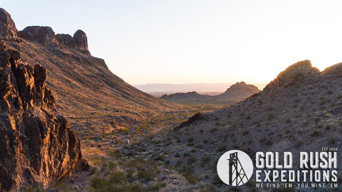
The Adams property is a 40 acre lode mining property located just outside of Oatman, Arizona. The region is well known for producing substantial gold deposits at depths to 1000’ historically.
The property has very little documented history but is referenced in some articles as a part of the Black Range or the Wrigley Mines. Both of which are documented gold producing properties. The Adams was noted by a previous owner as being integrated with the Wrigley.
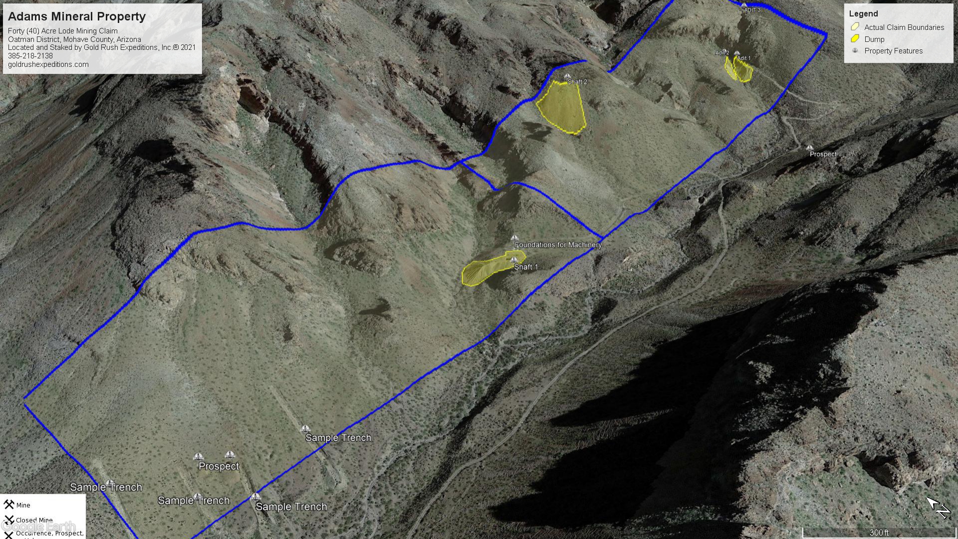
The property sits in a short canyon and consists of at least two (2) shafts and two (2) adits. The adits are accessible and have been mapped. The shafts have not been mapped or surveyed.
Samples were taken from inside the adits on veins and or visible deposits. Dump material was sampled with an emphasis on visible material. Assays were run on all of the material removed, vein material from inside the main adit had and assay range of .06 oz. to 2.15 oz. per ton of gold and 0.28 to 14 oz. of AG per ton. In addition, there were some copper samples taken that showed up to 2% per ton.
The main adit was completely surveyed and contained 2,710’ of linear workings. A winze near the face of one drift in the adit was not explored, it was estimated over 250’ and no working levels were seen.
The main shaft, ID Shaft 1, was laser measured from the surface and measured over 300’ in depth (capability of laser measurement is 300’) The shaft showed some loose timber and at least one likely working drift level. Concrete pads were inplace near the portal indicating heavy machinery likely used to pull ore cars on a headframe. The equipment and the headframe are no longer in place.
There is a small adit, noted as Adit 2, that has been largely covered by rock fall and was not accessible.
Adit 3 was a small cut that had largely filled with loose rubble. It is at the head of the ravine above Adits 1 and 2. It does have impressive dump material values and should be further investigated.
The site should be viewed as a Gold and Copper based property with some values in Silver.
The location is generally remote and the mines all will require a short hike to access as the roads to the mine portals are damaged and not passable.
There has been no milling conducted on the property which minimizes any environmental concerns. The property should be viewed as a brown-field development with significant documentation of the materials and the workings. Historical information is spotty and not complete in any manner.
Gold Rush Expeditions, Inc. does offer mining consultation services and assistance with permits for a small fee.
Training courses for underground work and exploration can be found here: https://stayoutstayalive.com/training/
The Adams property is a 40 acre lode mining property located just outside of Oatman, Arizona. The region is well known for producing substantial gold deposits at depths to 1000’ historically.
The property has very little documented history but is referenced in some articles as a part of the Black Range or the Wrigley Mines. Both of which are documented gold producing properties. The Adams was noted by a previous owner as being integrated with the Wrigley.
The property sits in a short canyon and consists of at least two (2) shafts and two (2) adits. The adits are accessible and have been mapped. The shafts have not been mapped or surveyed.
Samples were taken from inside the adits on veins and or visible deposits. Dump material was sampled with an emphasis on visible material. Assays were run on all of the material removed, vein material from inside the main adit had and assay range of .06 oz. to 2.15 oz. per ton of gold and 0.28 to 14 oz. of AG per ton. In addition, there were some copper samples taken that showed up to 2% per ton.
The main adit was completely surveyed and contained 2,710’ of linear workings. A winze near the face of one drift in the adit was not explored, it was estimated over 250’ and no working levels were seen.
The main shaft, ID Shaft 1, was laser measured from the surface and measured over 300’ in depth (capability of laser measurement is 300’) The shaft showed some loose timber and at least one likely working drift level. Concrete pads were inplace near the portal indicating heavy machinery likely used to pull ore cars on a headframe. The equipment and the headframe are no longer in place.
There is a small adit, noted as Adit 2, that has been largely covered by rock fall and was not accessible.
Adit 3 was a small cut that had largely filled with loose rubble. It is at the head of the ravine above Adits 1 and 2. It does have impressive dump material values and should be further investigated.
The site should be viewed as a Gold and Copper based property with some values in Silver.
The location is generally remote and the mines all will require a short hike to access as the roads to the mine portals are damaged and not passable.
There has been no milling conducted on the property which minimizes any environmental concerns. The property should be viewed as a brown-field development with significant documentation of the materials and the workings. Historical information is spotty and not complete in any manner.
Gold Rush Expeditions, Inc. does offer mining consultation services and assistance with permits for a small fee.
Training courses for underground work and exploration can be found here: https://stayoutstayalive.com.training/
Acres
Commodities
Type
40
Gold, Silver, Copper
Lode
Underground Dev
Surface Dump
Tailings
3,100 feet
60,801 tons
N/A
Access
Features
High Clearance 4WD
N/A
Gold Reserves
Silver Reserves
Copper Reserves
Platinum Reserves
Tungsten Reserves
Molybdenum Reserves
35,747 oz
280,803 oz
1,391,393 lbs
N/A
N/A
N/A
(385) 218-2138
or use our contact form below