Under Contract
Click to read more...
Property Overview
NOTE: Technical Report incomplete- Offered at wholesale until report is complete.
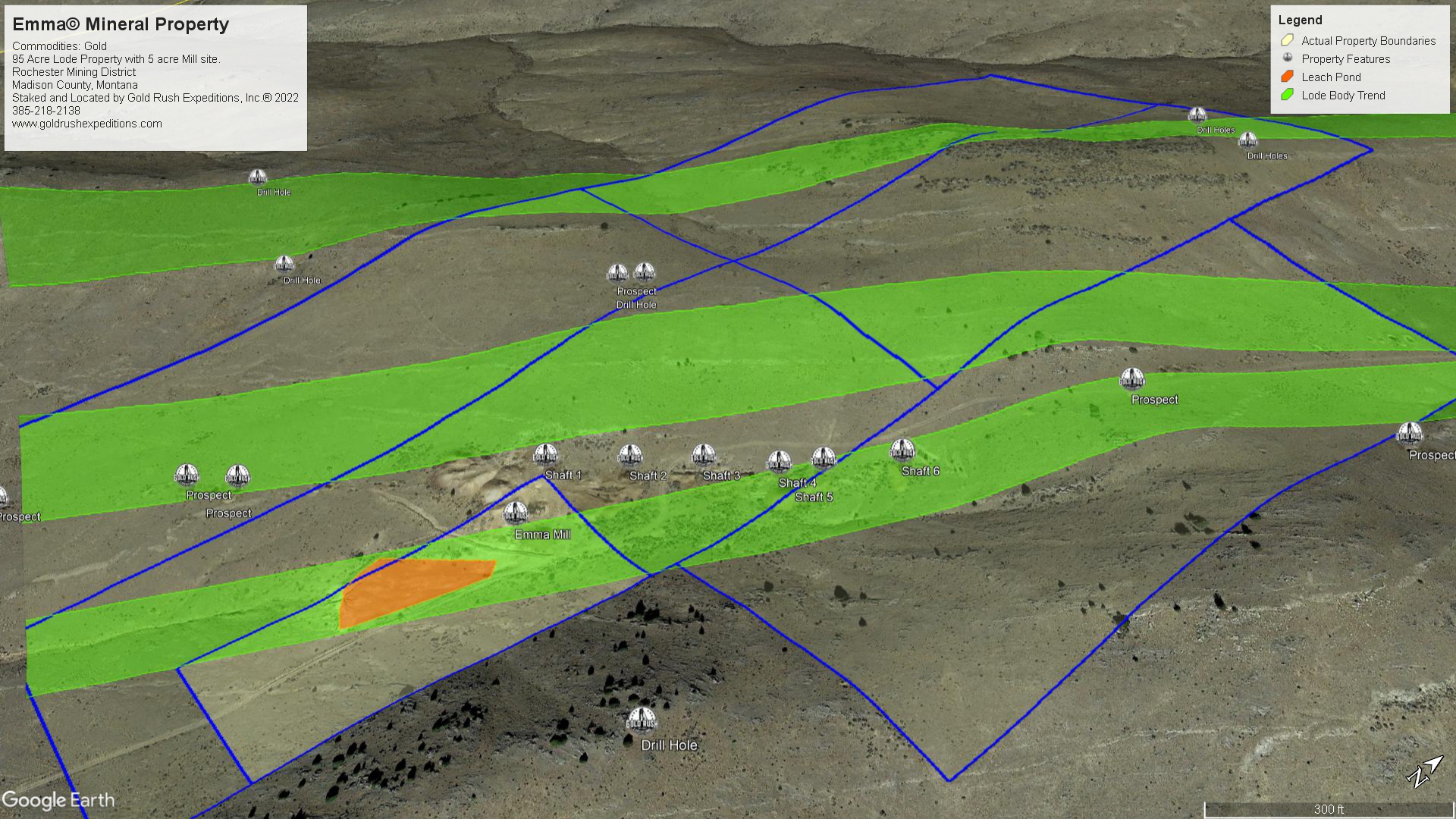
The Emma property is a 100 acre lot running along established and well defined metal lodes in quartz. The outcrops are visible and the claims are written to cover the apex of the lodes/veins without question.
The ores occur in quartz in a granite gneiss. The deposits were originally located in 1888 according to documentation when it consisted of several other properties, including the Emma, Rabbit, Rochester View, Montana and Blue Bird. These mines were located from surface outcrops of silver and lead. As the deposits were further explored, the quantity of lead diminished and the silver, gold and zinc quantity increased. The vein is reportedly a fissure vein in gneiss. It strikes broadly through in a north-easterly direction with great lateral extent. The pay streaks in the lodes have been measured from 3 inches wide to over 48 inches wide. Average depth of the veins is 42 inches. The lodes (veins) dip at 45 degrees on average.
The main shaft (at the mill) is measured at 615’ The bottom level is marked 700, but measures 615’ from the surface. There are three drift levels in the main shaft that chase parts of the veins north-easterly and southwesterly. The 615 level is roughly 20’ above a sump at the base of the incline shaft. The 615 gives good view of the hanging wall and high grade ore. It appears from survey that there is a good amount of ore that has been blocked and left. It may be that this ore was a lower quality than some of the higher grade ore that was shipping, or it may have simply been left to be mined when gold and silver prices were higher. The 615 drift runs 240’ to the southwest where there is a collapse. The drift continues and can be seen to continue as far as lights can reach, however it is unsafe to navigate the collapse.
The 615 drift runs northeasterly for 500’ where a muck wall has been built up. This does not appear to be the end of the drift, but significant effort was put into making a wall to close it off.
The other levels are less than 500’ in either direction and show some silver and lead deposits, but the visible gold and pyrites in sulphides are not prominent until the 615 level. Many surface and subsurface chip samples were taken and sent for assay.
Samples showed silver of 19.8 oz. to 34 oz per ton. Average silver value is 22.6 oz/T.
Gold ranged from less than 1/10 oz. to 3 oz per ton. Average gold assay from subsurface is 0.78 oz. per ton.
There are many other shafts on the property that were accessed for chip samples.
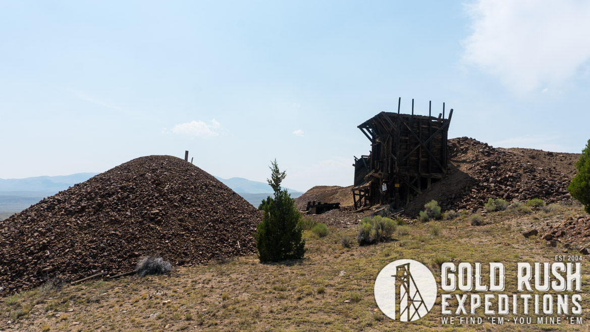
The Emma property contains a five (5) acre mill site in addition to 95 acres of lode property. The mill site is important as in later years (1921-1940) the mill processed ores for several of the large mines in the area with an advanced mill that was able to run 60 tons per day in flotation and table concentration. When the War Act shut the mine in 1940, the Emma breathed her last. The mill was dismantled and sold in 1942-1943 at a tax sale.
The property is accessible via county roads which are passable by standard 4wd vehicles.
This is an ideal property that could be developed from a small operation to a larger development with a little investment into the infrastructure. There is a property of similar structure but inferior mineral valuation which sold shares equaling $22M in 2020. By that standard this property should be 3x-4x more valuable.
Gold Rush Expeditions, Inc. does offer mining consultation services and assistance with permits for a small fee.
Training courses for underground work and exploration can be found here: https://stayoutstayalive.com/training/
NOTE: Technical Report incomplete- Offered at wholesale until report is complete.
The Emma property is a 100 acre lot running along established and well defined metal lodes in quartz. The outcrops are visible and the claims are written to cover the apex of the lodes/veins without question.
The ores occur in quartz in a granite gneiss. The deposits were originally located in 1888 according to documentation when it consisted of several other properties, including the Emma, Rabbit, Rochester View, Montana and Blue Bird. These mines were located from surface outcrops of silver and lead. As the deposits were further explored, the quantity of lead diminished and the silver, gold and zinc quantity increased. The vein is reportedly a fissure vein in gneiss. It strikes broadly through in a north-easterly direction with great lateral extent. The pay streaks in the lodes have been measured from 3 inches wide to over 48 inches wide. Average depth of the veins is 42 inches. The lodes (veins) dip at 45 degrees on average.
The main shaft (at the mill) is measured at 615’ The bottom level is marked 700, but measures 615’ from the surface. There are three drift levels in the main shaft that chase parts of the veins north-easterly and southwesterly. The 615 level is roughly 20’ above a sump at the base of the incline shaft. The 615 gives good view of the hanging wall and high grade ore. It appears from survey that there is a good amount of ore that has been blocked and left. It may be that this ore was a lower quality than some of the higher grade ore that was shipping, or it may have simply been left to be mined when gold and silver prices were higher. The 615 drift runs 240’ to the southwest where there is a collapse. The drift continues and can be seen to continue as far as lights can reach, however it is unsafe to navigate the collapse.
The 615 drift runs northeasterly for 500’ where a muck wall has been built up. This does not appear to be the end of the drift, but significant effort was put into making a wall to close it off.
The other levels are less than 500’ in either direction and show some silver and lead deposits, but the visible gold and pyrites in sulphides are not prominent until the 615 level. Many surface and subsurface chip samples were taken and sent for assay.
Samples showed silver of 19.8 oz. to 34 oz per ton. Average silver value is 22.6 oz/T.
Gold ranged from less than 1/10 oz. to 3 oz per ton. Average gold assay from subsurface is 0.78 oz. per ton.
There are many other shafts on the property that were accessed for chip samples.
The Emma property contains a five (5) acre mill site in addition to 95 acres of lode property. The mill site is important as in later years (1921-1940) the mill processed ores for several of the large mines in the area with an advanced mill that was able to run 60 tons per day in flotation and table concentration. When the War Act shut the mine in 1940, the Emma breathed her last. The mill was dismantled and sold in 1942-1943 at a tax sale.
The property is accessible via county roads which are passable by standard 4wd vehicles.
This is an ideal property that could be developed from a small operation to a larger development with a little investment into the infrastructure. There is a property of similar structure but inferior mineral valuation which sold shares equaling $22M in 2020. By that standard this property should be 3x-4x more valuable.
Gold Rush Expeditions, Inc. does offer mining consultation services and assistance with permits for a small fee.
Training courses for underground work and exploration can be found here: https://stayoutstayalive.com.training/
Acres
Commodities
Type
100
Gold, Silver, Lead, Zinc
Lode, Mill
Underground Dev
Surface Dump
Tailings
2,000 feet
156,000 tons
77,000 tons
Access
Features
4WD
60 tpd Mill, 156,000 Ton Dump, 77,000 tons tails. Average Gold 0.78 oz/T
Gold Reserves
Silver Reserves
Copper Reserves
Platinum Reserves
Tungsten Reserves
Molybdenum Reserves
121,929 oz
3,532,832 oz
N/A
N/A
N/A
N/A
(385) 218-2138
or use our contact form below