Click to read more...
Property Overview
The Ethel Leona is a large gold producing property in far eastern San Bernardino County, California. The mine is located within the Whipple Mountains mining district. This district is known for its large production of gold mining properties. The majority of the mines on the mountain have been removed from locatability by being located on what is now known as the Whipple Mountain Wilderness.
The Ethel Leona exists roughly 1.3 miles outside of the Wilderness boundary. There are good 4×4 roads which lead to the site and provide good access to the main workings. The mine has also been known as the Riverview, assumedly for its proximity to the Colorado River.
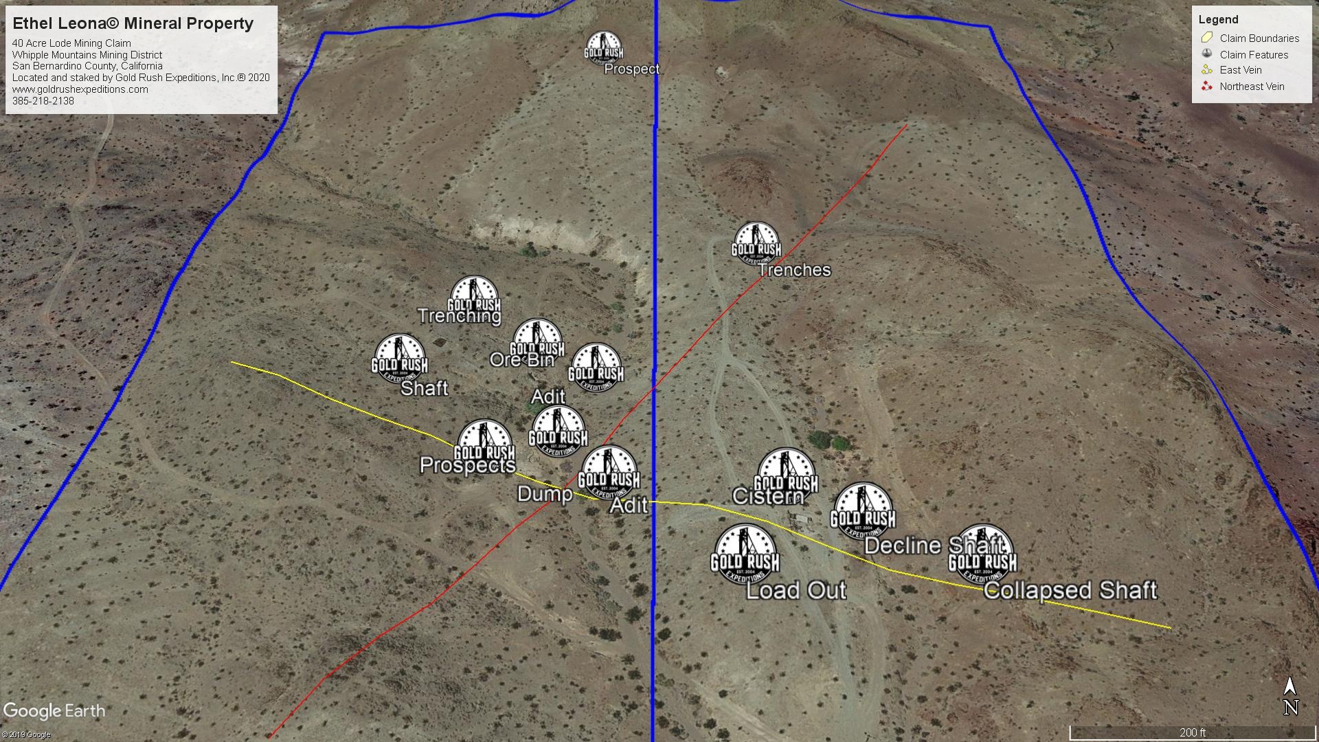
The mine consists of a series of adits and shafts working the general trending of two gold ore bodies. The gold is noted to be native in most pockets with lenses of minerals containing copper and silver. Average grade of the gold is .585 ounces to the ton based on production.
Surveyor assays varied widely across the property, showing general areas of the vein and deposits of gold vs. other minerals. The two defined veins on the property run NNE and ESE. The defined length, dip, and valuation of the veins is unknown and should be explored through a drilling program.
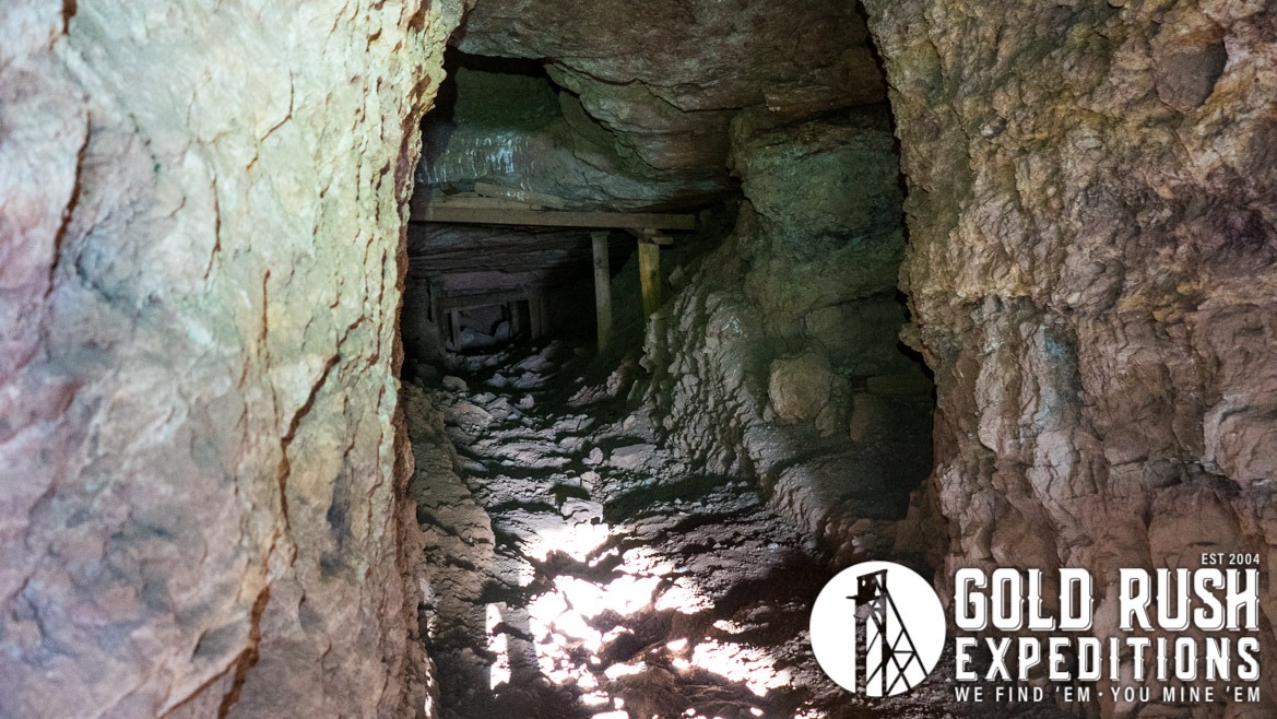
The mines are spread out across the vein system and there is only one adit of real significance. This adit is located on the eastern half of the property and cuts down at a 25-degree angle into the earth with various crosscuts. Approximately 270’ in length to where it is blocked. It has suffered from some fill near the bottom of the decline. This leads to a drift level as can be seen by the cut drifts running north and south.
A shorter adit, roughly 130’ shows some mineralization on a low ridge near the center of the claims. It runs generally horizontal with a cross-cut drift near 110’ This drift runs for an indefinite distance north and south.
On the western claim, there are a series of short shafts, from 25-100’. A trench has been cut out from one of the shafts and runs to a loadout in the lower wash. The ores in the region show more silver and lead and less gold as would be expected since the cuts are well off of the veins. South of the shafts there is an open stoping area that consists of a grouping of small adits and shafts which show some very impressive copper mineralization but only minimal gold-bearing veinlets.
The majority of the gold-bearing lode is located in the center of the east and west claims and runs generally ESE. Trenching north of this vein showed no significant mineralization of any sort and is thought to have been exploratory.
There is no water and the region is extremely dry. There is also no shade or shelter from the sun. This area will be brutal to work in the summer seasons and precautions should be taken to prevent heat exhaustion and exposure.
Gold Rush Expeditions, Inc. does offer mining consultation services and assistance with permits for a small fee.
Training courses for underground work and exploration can be found here: https://stayoutstayalive.com/training/
The Ethel Leona is a large gold producing property in far eastern San Bernardino County, California. The mine is located within the Whipple Mountains mining district. This district is known for its large production of gold mining properties. The majority of the mines on the mountain have been removed from locatability by being located on what is now known as the Whipple Mountain Wilderness.
The Ethel Leona exists roughly 1.3 miles outside of the Wilderness boundary. There are good 4×4 roads which lead to the site and provide good access to the main workings. The mine has also been known as the Riverview, assumedly for its proximity to the Colorado River.
The mine consists of a series of adits and shafts working the general trending of two gold ore bodies. The gold is noted to be native in most pockets with lenses of minerals containing copper and silver. Average grade of the gold is .585 ounces to the ton based on production.
Surveyor assays varied widely across the property, showing general areas of the vein and deposits of gold vs. other minerals. The two defined veins on the property run NNE and ESE. The defined length, dip, and valuation of the veins is unknown and should be explored through a drilling program.
The mines are spread out across the vein system and there is only one adit of real significance. This adit is located on the eastern half of the property and cuts down at a 25-degree angle into the earth with various crosscuts. Approximately 270’ in length to where it is blocked. It has suffered from some fill near the bottom of the decline. This leads to a drift level as can be seen by the cut drifts running north and south.
A shorter adit, roughly 130’ shows some mineralization on a low ridge near the center of the claims. It runs generally horizontal with a cross-cut drift near 110’ This drift runs for an indefinite distance north and south.
On the western claim, there are a series of short shafts, from 25-100’. A trench has been cut out from one of the shafts and runs to a loadout in the lower wash. The ores in the region show more silver and lead and less gold as would be expected since the cuts are well off of the veins. South of the shafts there is an open stoping area that consists of a grouping of small adits and shafts which show some very impressive copper mineralization but only minimal gold-bearing veinlets.
The majority of the gold-bearing lode is located in the center of the east and west claims and runs generally ESE. Trenching north of this vein showed no significant mineralization of any sort and is thought to have been exploratory.
There is no water and the region is extremely dry. There is also no shade or shelter from the sun. This area will be brutal to work in the summer seasons and precautions should be taken to prevent heat exhaustion and exposure.
Gold Rush Expeditions, Inc. does offer mining consultation services and assistance with permits for a small fee.
Training courses for underground work and exploration can be found here: https://stayoutstayalive.com.training/
Acres
Commodities
Type
40
Gold, Copper
Lode
Underground Dev
Surface Dump
Tailings
1,500 feet
65,817 tons
N/A
Access
Features
High Clearance 4WD
Cistern Remains
Gold Reserves
Silver Reserves
Copper Reserves
Platinum Reserves
Tungsten Reserves
Molybdenum Reserves
48,479 oz
N/A
Undefined
N/A
N/A
N/A
(385) 218-2138
or use our contact form below