Sold
Click to read more...
Property Overview
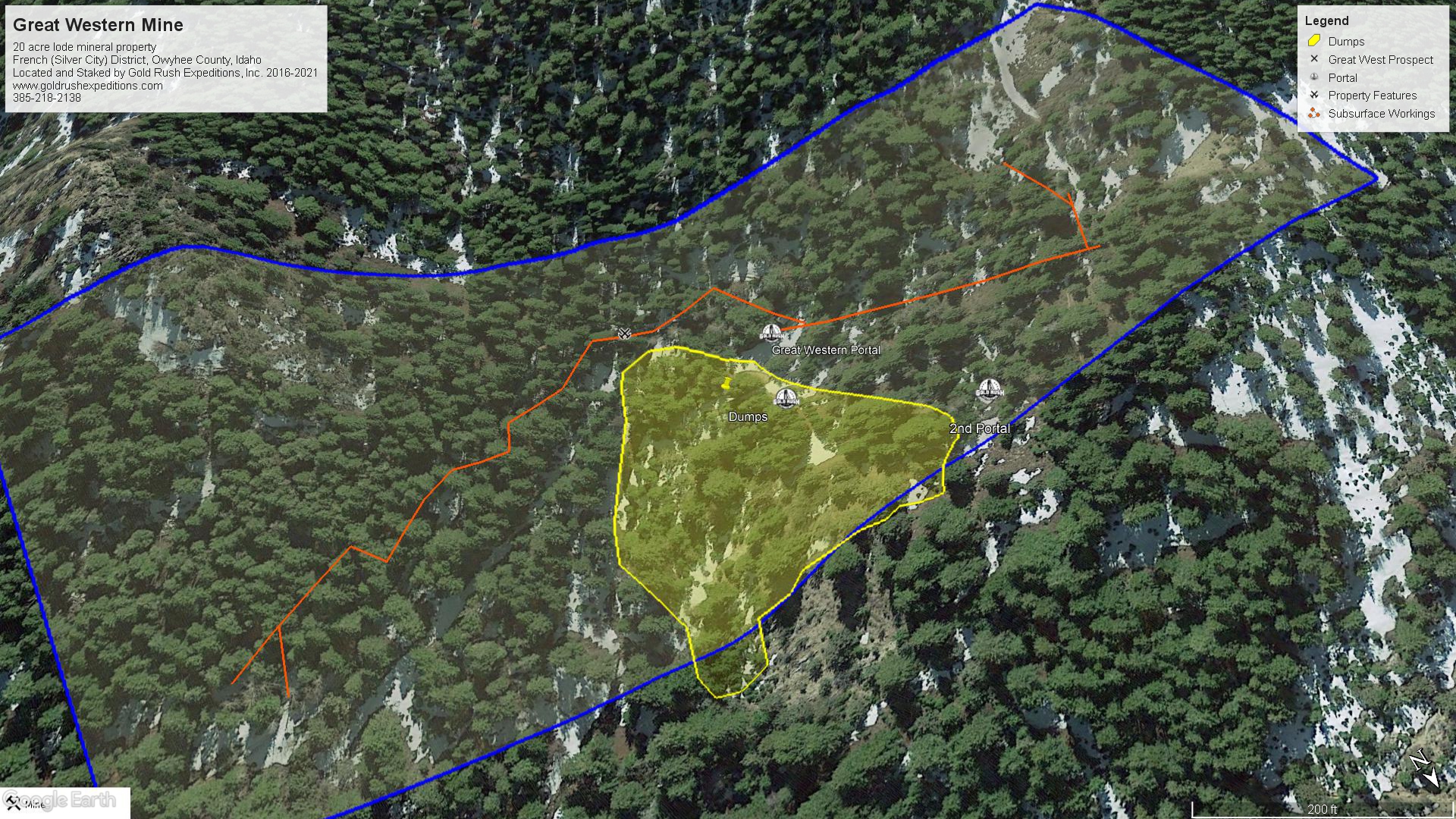
The Great Western Mine is a 20-acre lode mineral property located in the Silver City region. The mine is named for the Mining Company which originally developed it, Great Western Mines Co. The mine is located on the western slope of French Gulch, near the head of the Gulch. The property is in the French Mining District, in Owyhee County, Idaho. The Mine is roughly 1.7 air miles from Silver City in the heart of the Silver City Mines.
The Great Western is one of the only properties available in the Silver City region, the region was made non-locatable in 2018 and all new claims have been nullified by the BLM.
The mine is one of the largest accessible deposits in the region that is not fully collapsed. The drifts undercut the eastern extensions of the famously rich Oro Fino and Golden Chariot veins which were worked exclusively for gold deposits.
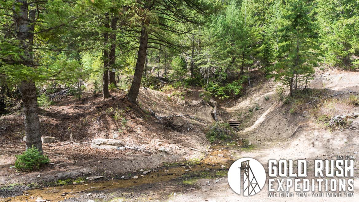
The portal was reclaimed by way of a culvert and a gate in 2012-2013 according to sparse records. The portal was in good condition prior to this and boasted a stout gate and a solid structure over the portal.
The portal accesses at least 6,000’ of subsurface workings following the Oro Fino and the Golden Chariot vein. There is documented to be at least 8,000’ of development, but this is unconfirmed. The Oro Fino vein which carried values averaging 4 oz/T in gold and 50 oz/T in silver and the Golden Chariot veins. Both are gold veins and the mine has produced only gold, despite its proximity to Silver City. Silver has been discarded in the dumps or taken out and not accounted for. This is further quantified by assay returns which show excellent values in silver and very low values in gold. Samples were handpicked from the dump at the top, middle and base of the dump.
The waste dumps on the claim show quartz, some lead and silver, and iron. There is an estimated 80k tons of waste dump outside of the main adit. This is a little less than would be expected of 6,000’ of drifting and undefined stoping efforts; however, the dumps are on a steep drainage and may have been washed by erosion over the past 70 years.
There are a number of concrete foundations for houses, winches, and engines around the property, further asserting the level of development done at the property.
The Mine is located in a high elevation (6400’) relative to the area and will likely see substantial snowpack for at least 3 months out of the year (Dec-Feb).
A long road winds up the mountain to the Great Western Mine. This road is in relatively good condition and could be traversed by most any high clearance 4WD or UTV. Vehicles with a long wheelbase or trailers will have some additional challenges with dips and steep ascents.
The mine is discharging a small amount of water that was not tested but is overall clear and shows little visible contamination. The mine itself has 6-8 inches of water in the entrance, this from the culverting and build up in the adit which is allowing the water to pool in the mine instead of flowing out as designed. The water dumping from the adit was clear but washed over quartz, oxidized iron, and some pyrites. Surveyors saw no visible gold in the runoff, which is to be expected after such a recent reclamation project which no doubt changed the structure of the site and compromised the historical integrity.
The property is centered on the old mine camp and there is substantial flat ground for trailers or other equipment staging.
Gold Rush Expeditions, Inc. does offer mining consultation services and assistance with permits for a small fee.
Training courses for underground work and exploration can be found here: https://stayoutstayalive.com/training/
The Great Western Mine is a 20-acre lode mineral property located in the Silver City region. The mine is named for the Mining Company which originally developed it, Great Western Mines Co. The mine is located on the western slope of French Gulch, near the head of the Gulch. The property is in the French Mining District, in Owyhee County, Idaho. The Mine is roughly 1.7 air miles from Silver City in the heart of the Silver City Mines.
The Great Western is one of the only properties available in the Silver City region, the region was made non-locatable in 2018 and all new claims have been nullified by the BLM.
The mine is one of the largest accessible deposits in the region that is not fully collapsed. The drifts undercut the eastern extensions of the famously rich Oro Fino and Golden Chariot veins which were worked exclusively for gold deposits.
The portal was reclaimed by way of a culvert and a gate in 2012-2013 according to sparse records. The portal was in good condition prior to this and boasted a stout gate and a solid structure over the portal.
The portal accesses at least 6,000’ of subsurface workings following the Oro Fino and the Golden Chariot vein. There is documented to be at least 8,000’ of development, but this is unconfirmed. The Oro Fino vein which carried values averaging 4 oz/T in gold and 50 oz/T in silver and the Golden Chariot veins. Both are gold veins and the mine has produced only gold, despite its proximity to Silver City. Silver has been discarded in the dumps or taken out and not accounted for. This is further quantified by assay returns which show excellent values in silver and very low values in gold. Samples were handpicked from the dump at the top, middle and base of the dump.
The waste dumps on the claim show quartz, some lead and silver, and iron. There is an estimated 80k tons of waste dump outside of the main adit. This is a little less than would be expected of 6,000’ of drifting and undefined stoping efforts; however, the dumps are on a steep drainage and may have been washed by erosion over the past 70 years.
There are a number of concrete foundations for houses, winches, and engines around the property, further asserting the level of development done at the property.
The Mine is located in a high elevation (6400’) relative to the area and will likely see substantial snowpack for at least 3 months out of the year (Dec-Feb).
A long road winds up the mountain to the Great Western Mine. This road is in relatively good condition and could be traversed by most any high clearance 4WD or UTV. Vehicles with a long wheelbase or trailers will have some additional challenges with dips and steep ascents.
The mine is discharging a small amount of water that was not tested but is overall clear and shows little visible contamination. The mine itself has 6-8 inches of water in the entrance, this from the culverting and build up in the adit which is allowing the water to pool in the mine instead of flowing out as designed. The water dumping from the adit was clear but washed over quartz, oxidized iron, and some pyrites. Surveyors saw no visible gold in the runoff, which is to be expected after such a recent reclamation project which no doubt changed the structure of the site and compromised the historical integrity.
The property is centered on the old mine camp and there is substantial flat ground for trailers or other equipment staging.
Gold Rush Expeditions, Inc. does offer mining consultation services and assistance with permits for a small fee.
Training courses for underground work and exploration can be found here: https://stayoutstayalive.com.training/
Acres
Commodities
Type
20
Gold, Silver
Lode
Underground Dev
Surface Dump
Tailings
6,000 feet
80,325 tons
N/A
Access
Features
Good 4WD Access
N/A
Gold Reserves
Silver Reserves
Copper Reserves
Platinum Reserves
Tungsten Reserves
Molybdenum Reserves
6,024 oz
508,698 oz
N/A
N/A
N/A
N/A
(385) 218-2138
or use our contact form below