Click to read more...
Property Overview
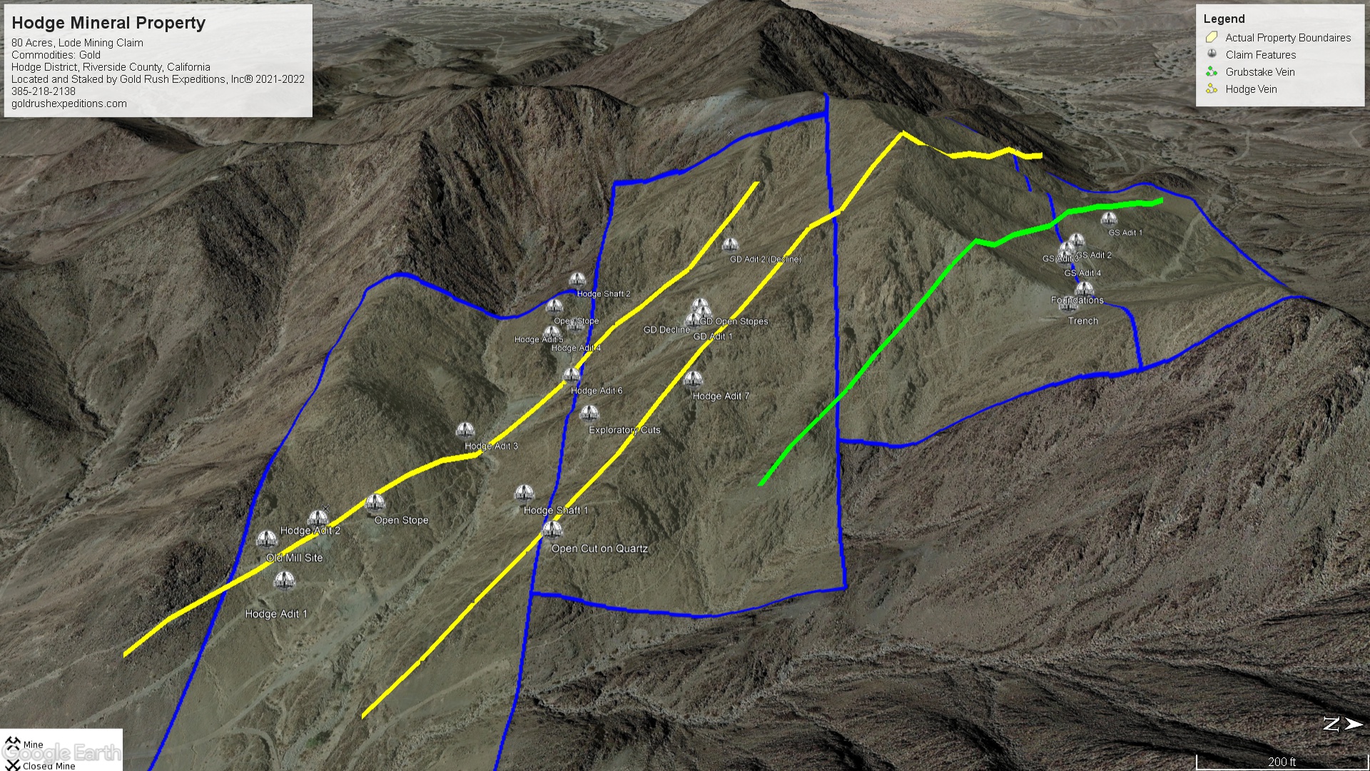
The Hodge Mineral Property is an 80 acre lode property. The claims are blocked to cover the surface and subsurface workings of the Granddaddy, the Grubstake and the Hodge mine. The mines are all part of the Mule Mountain or Hodge mining district. This district was worked specifically for native gold in quartz. The mines are very, very old. Likely dating to the 1500s or there about. Spanish and indiginous miners put extensive efforts into the surface gold deposits on this property. When the mines were first located in 1823, it was reported that there was an ancient wood mill at the base of the canyon. This mill contained no metal nails, banding or other implements as would be expected. The miners stated that the mill was extremely old but build with an amazing degree of skill.
The mines in the region are unique in the fact that they have only been worked for native gold. Several documents discuss that the gold is found in wide, iron stained quartz bodies. The Hodge vein was defined in 1869, it is reported to be fifty to one hundred feet in width and runs generally north on a flat plane. The length is undetermined. In 1890, the Grubstake vein was defined on the north slope of a saddle. The Hodge Mine was located on the south facing slope of the saddle. This inspired more development between the two properties and the Granddaddy mines were staked in 1871 and reported to have native gold in quartz worth up to $300 per ton (with gold at $20 per ounce, that would be 15 ounces of gold per ton).
The mines historically have been plagued by their location. Just as the old spanish miners noted, there is little to no water. Rainfall in the area is non-existant. This makes any sort of mining very difficult and it also makes it difficult to keep your workers alive.
The Salton sea is just west of the Hodge and despite the name offers no water to the area. Reports state that when the Rainbow and Roosevelt were active in the 1920s, they shipped in barrels of water at a rate of $4.00 per barrel. In todays dollars, that would be $28 per gallon of water.
The mines were worked by Hodge Bros Mining up into the 1930s. The Hodge Bros. shipped their ore to Palo Verde for processing. They also took water from a spring in the valley, pumping the water 3.5 miles to the camp at the Hodge. Drought in the late 1920s dried up the well and the Hodge Bros. abandoned operations but held the property. The property was sold off to a group of Spanish miners in 1953. There is no further record of any development at the site.
The mines are located in an MRZ3-a mineral zone that indicates the area has high potential for mineral resources but the extent of those mineral resources is unknown. There are no reported reserves blocked or reserved. With a proper mineral exploration to determine the resource potential the area is likely to move up a mineral classification.
The Hodge is a high value property that could potentially be worked year-round as long as the operators take into account the extreme heat in summer months. There are no resources on the claims and claimant should plan for this when executing a plan to work the mine. Historically water was pumped to the mine from 3.5 miles away.
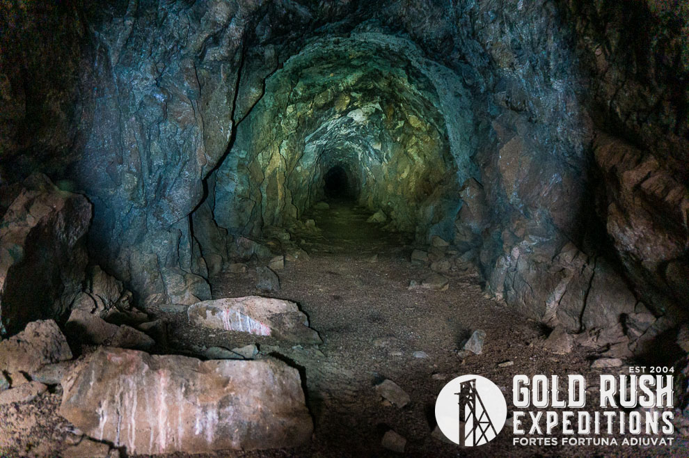
A haulage tunnel was cut in unmineralized rock that was used to access drifts and stopes of the workings higher on the ridge. This indicates that most of the workings of the Hodge are interconnected. Today you can see where this haulage tunnel was located, however it has been either blasted shut or eroded over years of nonuse.
It is reported historically that the adits of the Hodges had little to no timbering used to support the mine since the hard rock was so competent. Today the drift workings are intact with little to no collapse due to the structure of the rock. The adits were reported as open and dry in 1958. The openings are still very dry today but gated.
Gold Rush Expeditions, Inc. does not recommend that anyone undertake underground or subsurface exploration unless they are well trained with proper equipment and protocols. Access to the subsurface workings does require a permit for exploration. An exploration permit requires a Notice of Operation and will require a bond to fix or replace the gates that must be removed to access the mines.
Gold Rush Expeditions, Inc. does offer mining consultation services and assistance with permits for a small fee.
Training courses for underground work and exploration can be found here: https://stayoutstayalive.com/training/
The Hodge Mineral Property is an 80 acre lode property. The claims are blocked to cover the surface and subsurface workings of the Granddaddy, the Grubstake and the Hodge mine. The mines are all part of the Mule Mountain or Hodge mining district. This district was worked specifically for native gold in quartz. The mines are very, very old. Likely dating to the 1500s or there about. Spanish and indiginous miners put extensive efforts into the surface gold deposits on this property. When the mines were first located in 1823, it was reported that there was an ancient wood mill at the base of the canyon. This mill contained no metal nails, banding or other implements as would be expected. The miners stated that the mill was extremely old but build with an amazing degree of skill.
The mines in the region are unique in the fact that they have only been worked for native gold. Several documents discuss that the gold is found in wide, iron stained quartz bodies. The Hodge vein was defined in 1869, it is reported to be fifty to one hundred feet in width and runs generally north on a flat plane. The length is undetermined. In 1890, the Grubstake vein was defined on the north slope of a saddle. The Hodge Mine was located on the south facing slope of the saddle. This inspired more development between the two properties and the Granddaddy mines were staked in 1871 and reported to have native gold in quartz worth up to $300 per ton (with gold at $20 per ounce, that would be 15 ounces of gold per ton).
The mines historically have been plagued by their location. Just as the old spanish miners noted, there is little to no water. Rainfall in the area is non-existant. This makes any sort of mining very difficult and it also makes it difficult to keep your workers alive.
The Salton sea is just west of the Hodge and despite the name offers no water to the area. Reports state that when the Rainbow and Roosevelt were active in the 1920s, they shipped in barrels of water at a rate of $4.00 per barrel. In todays dollars, that would be $28 per gallon of water.
The mines were worked by Hodge Bros Mining up into the 1930s. The Hodge Bros. shipped their ore to Palo Verde for processing. They also took water from a spring in the valley, pumping the water 3.5 miles to the camp at the Hodge. Drought in the late 1920s dried up the well and the Hodge Bros. abandoned operations but held the property. The property was sold off to a group of Spanish miners in 1953. There is no further record of any development at the site.
The mines are located in an MRZ3-a mineral zone that indicates the area has high potential for mineral resources but the extent of those mineral resources is unknown. There are no reported reserves blocked or reserved. With a proper mineral exploration to determine the resource potential the area is likely to move up a mineral classification.
The Hodge is a high value property that could potentially be worked year-round as long as the operators take into account the extreme heat in summer months. There are no resources on the claims and claimant should plan for this when executing a plan to work the mine. Historically water was pumped to the mine from 3.5 miles away.
A haulage tunnel was cut in unmineralized rock that was used to access drifts and stopes of the workings higher on the ridge. This indicates that most of the workings of the Hodge are interconnected. Today you can see where this haulage tunnel was located, however it has been either blasted shut or eroded over years of nonuse.
It is reported historically that the adits of the Hodges had little to no timbering used to support the mine since the hard rock was so competent. Today the drift workings are intact with little to no collapse due to the structure of the rock. The adits were reported as open and dry in 1958. The openings are still very dry today but gated.
Gold Rush Expeditions, Inc. does not recommend that anyone undertake underground or subsurface exploration unless they are well trained with proper equipment and protocols. Access to the subsurface workings does require a permit for exploration. An exploration permit requires a Notice of Operation and will require a bond to fix or replace the gates that must be removed to access the mines.
Gold Rush Expeditions, Inc. does offer mining consultation services and assistance with permits for a small fee.
Training courses for underground work and exploration can be found here: https://stayoutstayalive.com.training/
Acres
Commodities
Type
80
Gold, Silver, Copper, Platinum
Lode
Underground Dev
Surface Dump
Tailings
4,700 feet
320,000 tons
20,000 tons
Access
Features
4WD
Old Mill, Mining Camp
Gold Reserves
Silver Reserves
Copper Reserves
Platinum Reserves
Tungsten Reserves
Molybdenum Reserves
Undefined
Undefined
Undefined
Undefined
N/A
N/A
(385) 218-2138
or use our contact form below