Click to read more...
Property Overview
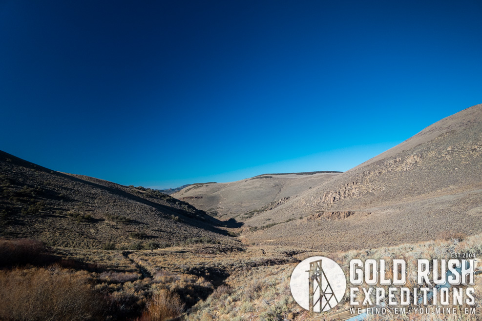
The Ledbetter Canyon property is a very remote property located in southern central Nevada. The property is within the mineralized zone of other monster sites such as Round Mountain, Wall Canyon and the East Golden. Sitting on the western edge of a wilderness study area, the property boasts excellent high clearance 4WD access and can be easily navigated by most full size vehicles. The property is at 8700', which is extremely high for Nevada standards. The mine was reportedly located in 1923 on exposed veins of native gold in fat quartz veins running in county rock. The mine was purchased in 1927 by AH Ferir, who lived on the property and mined until his death in 1959(?).
The main work on the mine was completed by Ferir. From 1932-1937 he hand sorted and milled 400 tons using a Gibson Crusher and classifier. This was replaced by a 14 ton Ellis Mill in 1938-39. Mr. Ferir reportedly ignored the 1941 War Act and continued to live and operate his mine. Production reportedly slowed due to Mr. Ferir's health and age.
Ores were reported to average 1/2 ounce per ton and paid well enough to build a stout homestead, a garage, a work shop and a mill building. The Mill is reported to have burned in 1973. The garage which was built with masonry walls can still be noted from its remnants today.
Several small companies traded and sold the mine after Mr. Ferir's death but no production was ever recorded.
The mine was maintained well into the early 1980s the last assessment work was recorded in 1986 and the mine has not operated since.
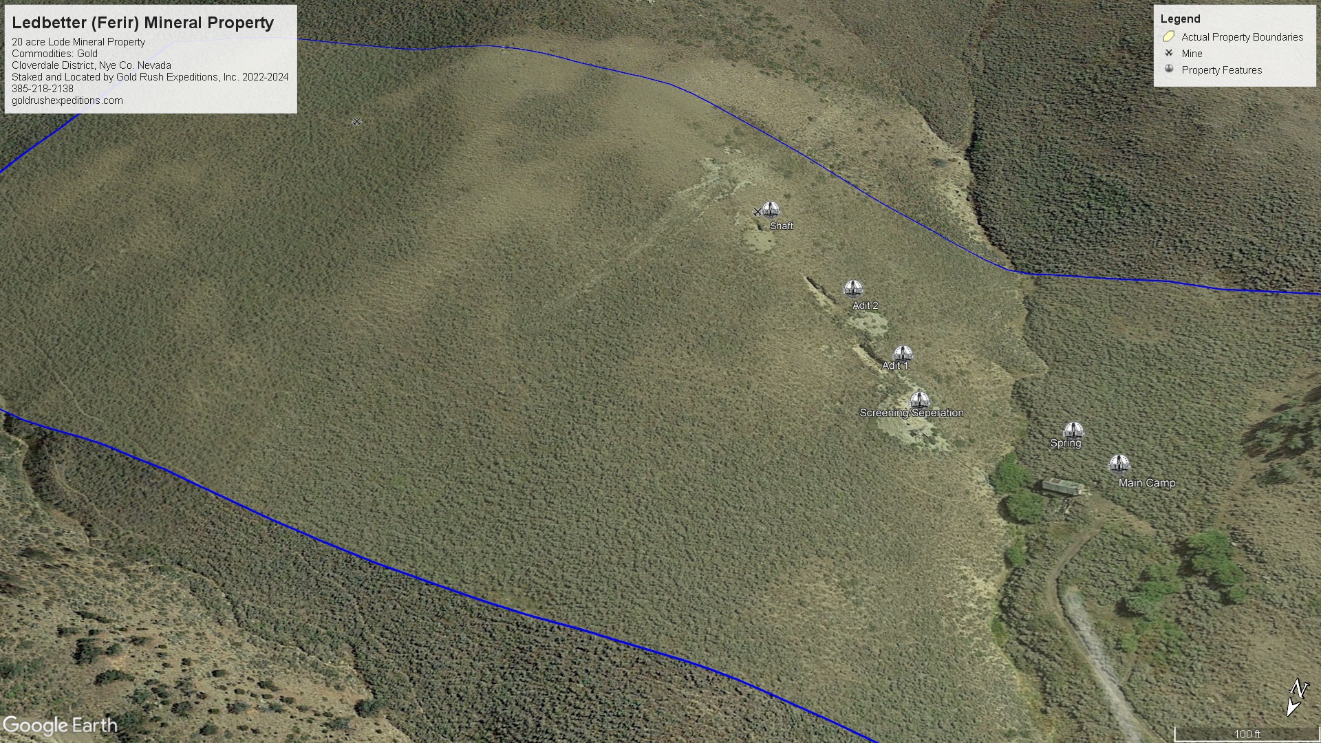
The mine is made up of two main adits that intersect with a shaft. There are several of the broken quartz veins that that can be seen in the stopes of the mine. The veins run generally E/W as a rule but there were two large quartz bodies noted that run ENE. Some native gold was noted in this deposit.
Gold appears in the quartz and in an andesite type of material which carries some small gems in vugs of various size. The primary ore is quartz running with dark iron staining.
Surveyor assets of chip samples on vein material in the mine returns values ranging from 0.85 oz/T to 4.31 oz/T in Gold. Average grade of chip samples is 2.35 oz/T AU. Material from the dumps averaged 0.61 oz/T AU. Minimal values of silver were noted.
Tails are present below the main cabin, these tails assayed 0.032 oz/AU on average.
There are over 500' of subsurface development on the property. This is largely cut into a dark grey rhyolite county rock.
This mine is ideal for a small operation due to its remote location. The cabin is rough, but usable with some clean up effort. While there is no ownership of the buildings or equipment stated or implied, it is completely legal to use these items at your discretion.
The mine has been defined by the USGS as a site of high potential for gold deposition. Its location within the vicinity of the East Golden, Round Mountain and other major gold mines make it a very likely candidate for much more expansion and profitable development.
Gold Rush Expeditions, Inc. does offer mining consultation services and assistance with permits for a small fee.
Training courses for underground work and exploration can be found here: https://stayoutstayalive.com/training/
The Ledbetter Canyon property is a very remote property located in southern central Nevada. The property is within the mineralized zone of other monster sites such as Round Mountain, Wall Canyon and the East Golden. Sitting on the western edge of a wilderness study area, the property boasts excellent high clearance 4WD access and can be easily navigated by most full size vehicles. The property is at 8700', which is extremely high for Nevada standards. The mine was reportedly located in 1923 on exposed veins of native gold in fat quartz veins running in county rock. The mine was purchased in 1927 by AH Ferir, who lived on the property and mined until his death in 1959(?).
The main work on the mine was completed by Ferir. From 1932-1937 he hand sorted and milled 400 tons using a Gibson Crusher and classifier. This was replaced by a 14 ton Ellis Mill in 1938-39. Mr. Ferir reportedly ignored the 1941 War Act and continued to live and operate his mine. Production reportedly slowed due to Mr. Ferir's health and age.
Ores were reported to average 1/2 ounce per ton and paid well enough to build a stout homestead, a garage, a work shop and a mill building. The Mill is reported to have burned in 1973. The garage which was built with masonry walls can still be noted from its remnants today.
Several small companies traded and sold the mine after Mr. Ferir's death but no production was ever recorded.
The mine was maintained well into the early 1980s the last assessment work was recorded in 1986 and the mine has not operated since.
The mine is made up of two main adits that intersect with a shaft. There are several of the broken quartz veins that that can be seen in the stopes of the mine. The veins run generally E/W as a rule but there were two large quartz bodies noted that run ENE. Some native gold was noted in this deposit.
Gold appears in the quartz and in an andesite type of material which carries some small gems in vugs of various size. The primary ore is quartz running with dark iron staining.
Surveyor assets of chip samples on vein material in the mine returns values ranging from 0.85 oz/T to 4.31 oz/T in Gold. Average grade of chip samples is 2.35 oz/T AU. Material from the dumps averaged 0.61 oz/T AU. Minimal values of silver were noted.
Tails are present below the main cabin, these tails assayed 0.032 oz/AU on average.
There are over 500' of subsurface development on the property. This is largely cut into a dark grey rhyolite county rock.
This mine is ideal for a small operation due to its remote location. The cabin is rough, but usable with some clean up effort. While there is no ownership of the buildings or equipment stated or implied, it is completely legal to use these items at your discretion.
The mine has been defined by the USGS as a site of high potential for gold deposition. Its location within the vicinity of the East Golden, Round Mountain and other major gold mines make it a very likely candidate for much more expansion and profitable development.
Gold Rush Expeditions, Inc. does offer mining consultation services and assistance with permits for a small fee.
Training courses for underground work and exploration can be found here: https://stayoutstayalive.com.training/
Acres
Commodities
Type
20
Gold, Silver, Copper
Lode, Mill
Underground Dev
Surface Dump
Tailings
500 feet
25,000 tons
1,000 tons
Access
Features
High Clearance 4WD
Cabin, Mine Camp
Gold Reserves
Silver Reserves
Copper Reserves
Platinum Reserves
Tungsten Reserves
Molybdenum Reserves
Undefined
Undefined
Undefined
N/A
N/A
N/A
(385) 218-2138
or use our contact form below