Click to read more...
Property Overview
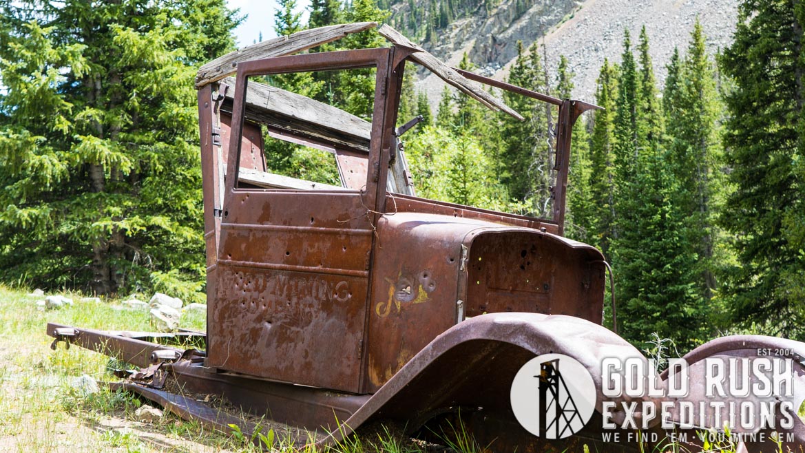
The Salamander property is a 20-acre lode mining property located in the Monte Cristo district, on the Monte Cristo Creek. The Monte Cristo district is a sub-district of the Breckenridge District. The site is a high value gold deposit with visible deposition of gold in nuggets and in quartz veins. Much of the gold samples have been left on the surface indicating the gold values found underground were significantly higher, leading to the lesser value material being discarded.
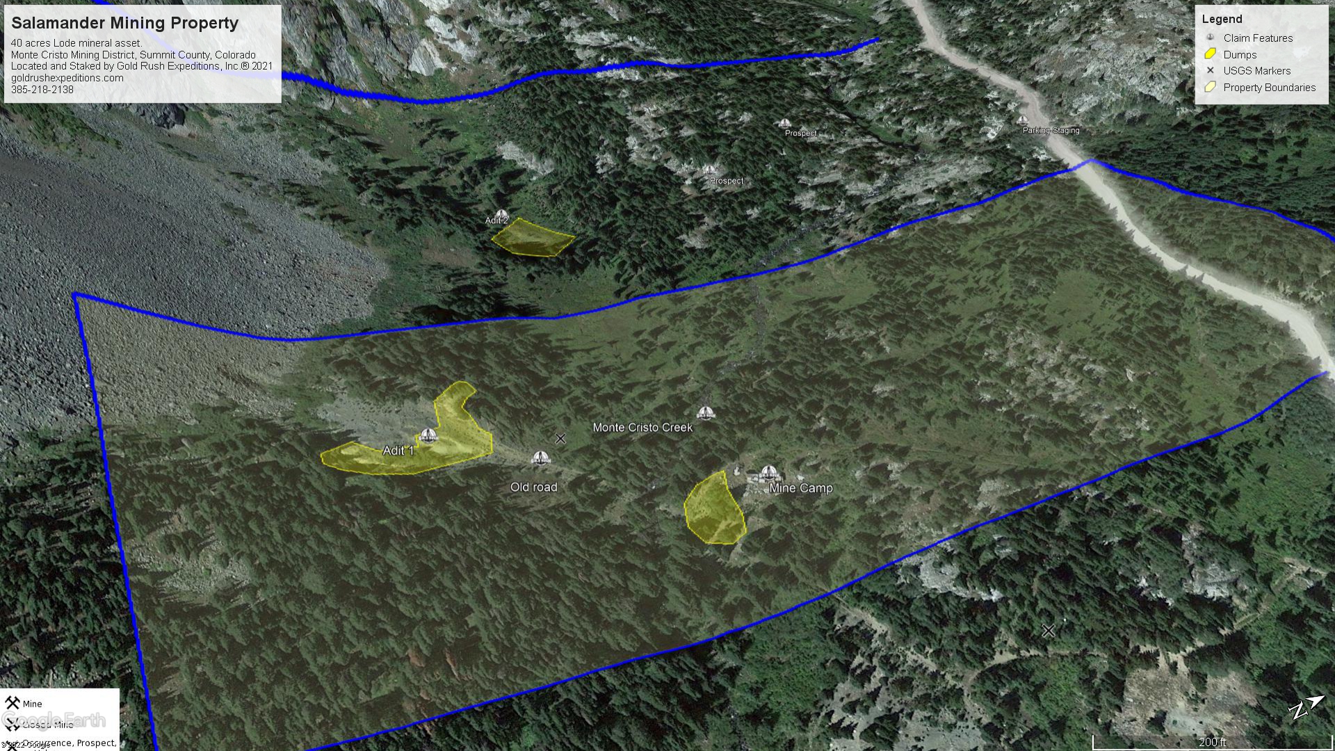
The Salamander Mine consists of two adits that have been driven generally west and northwest intercepting multiple gold veins. There is no current access to the subsurface workings and the workings were reported as collapsed in 1921.
Based on the sizing of the ore car rail the mine is rather substantial. There is light water discharge from the southernmost adit. Subsurface workings are expected to be approximately eighteen hundred (1800) feet or thereabout. This based on historical assessment and measurement of dumps and disturbance at the site. Ore was taken out of the mine by metal carts. From this point it was hand sorted and the best ore was taken by truck east roughly ¾ mile to a mill site. Heads were native gold with some quartz.
Surveyors at the site noted several dump piles where visible gold was seen. This gold appears on quartz and on some oxidized material. Assays from the dump piles on the Salamander averaged 1.34 oz. gold and 0.389 oz. silver per ton. Select material from the dumps near the portals assayed as high as 6.5 ounces of gold per ton.
The property is defined a gold producing property due to the proliferation of native gold. There is some residual silver that can be found in the dumps but it is of little value. Copper is reported to have been recovered at a rate of ten (10) to thirteen (13) percent per ton. Assays for copper were not processed by Gold Rush Expeditions.
The main portal of the mining claim sits at an altitude of just over eleven thousand (11,000) feet. The second portal is at eleven thousand one hundred and fifty (11,150) feet. Monte Cristo Creek runs through the property and forms up near the Blue Lakes. Surveyors took pan samples (2-5lbs of creek material) and reported visible gold in small nuggets was found in five out of six pan samples.
A small mining camp exists near the center of the eastern edge of the property. This camp consists of a few buildings and other mining remnants. The stairs and workspace around the cabins have had hand selected stones laid in and then mortar placed to keep them in place. There are some writings from the original miners in the mortar. Ores are staged up at the mine camp and the material showed very high grade. The location of the ore could not be proven, so samples were assayed on their own merit and not tied to either access portal.
There is no drive-up access to the mine at current. It would be possible to cut a road to the mine but permitting and bonding would be required.
This is an ideal property for a small miner or a team of small operators. Gold could be recovered from dump piles and from the creek. The gold content is high so it will not take a significant amount of material to garner a decent return. The development of the site would be dependent on the operator and it would not require much to open the old portals and begin proper mining in earnest.
Gold Rush Expeditions, Inc. does offer mining consultation services and assistance with permits for a small fee.
Training courses for underground work and exploration can be found here: https://stayoutstayalive.com/training/
The Salamander property is a 20-acre lode mining property located in the Monte Cristo district, on the Monte Cristo Creek. The Monte Cristo district is a sub-district of the Breckenridge District. The site is a high value gold deposit with visible deposition of gold in nuggets and in quartz veins. Much of the gold samples have been left on the surface indicating the gold values found underground were significantly higher, leading to the lesser value material being discarded.
The Salamander Mine consists of two adits that have been driven generally west and northwest intercepting multiple gold veins. There is no current access to the subsurface workings and the workings were reported as collapsed in 1921.
Based on the sizing of the ore car rail the mine is rather substantial. There is light water discharge from the southernmost adit. Subsurface workings are expected to be approximately eighteen hundred (1800) feet or thereabout. This based on historical assessment and measurement of dumps and disturbance at the site. Ore was taken out of the mine by metal carts. From this point it was hand sorted and the best ore was taken by truck east roughly ¾ mile to a mill site. Heads were native gold with some quartz.
Surveyors at the site noted several dump piles where visible gold was seen. This gold appears on quartz and on some oxidized material. Assays from the dump piles on the Salamander averaged 1.34 oz. gold and 0.389 oz. silver per ton. Select material from the dumps near the portals assayed as high as 6.5 ounces of gold per ton.
The property is defined a gold producing property due to the proliferation of native gold. There is some residual silver that can be found in the dumps but it is of little value. Copper is reported to have been recovered at a rate of ten (10) to thirteen (13) percent per ton. Assays for copper were not processed by Gold Rush Expeditions.
The main portal of the mining claim sits at an altitude of just over eleven thousand (11,000) feet. The second portal is at eleven thousand one hundred and fifty (11,150) feet. Monte Cristo Creek runs through the property and forms up near the Blue Lakes. Surveyors took pan samples (2-5lbs of creek material) and reported visible gold in small nuggets was found in five out of six pan samples.
A small mining camp exists near the center of the eastern edge of the property. This camp consists of a few buildings and other mining remnants. The stairs and workspace around the cabins have had hand selected stones laid in and then mortar placed to keep them in place. There are some writings from the original miners in the mortar. Ores are staged up at the mine camp and the material showed very high grade. The location of the ore could not be proven, so samples were assayed on their own merit and not tied to either access portal.
There is no drive-up access to the mine at current. It would be possible to cut a road to the mine but permitting and bonding would be required.
This is an ideal property for a small miner or a team of small operators. Gold could be recovered from dump piles and from the creek. The gold content is high so it will not take a significant amount of material to garner a decent return. The development of the site would be dependent on the operator and it would not require much to open the old portals and begin proper mining in earnest.
Gold Rush Expeditions, Inc. does offer mining consultation services and assistance with permits for a small fee.
Training courses for underground work and exploration can be found here: https://stayoutstayalive.com.training/
Acres
Commodities
Type
20
Gold, Silver, Copper, Molybdenum
Lode
Underground Dev
Surface Dump
Tailings
1,800 feet
69,958 tons
N/A
Access
Features
High Clearance 2WD- short hike to site
N/A
Gold Reserves
Silver Reserves
Copper Reserves
Platinum Reserves
Tungsten Reserves
Molybdenum Reserves
119,515 oz
24,817 oz
Undefined
N/A
N/A
Undefined
(385) 218-2138
or use our contact form below