Under Contract
Click to read more...
Property Overview
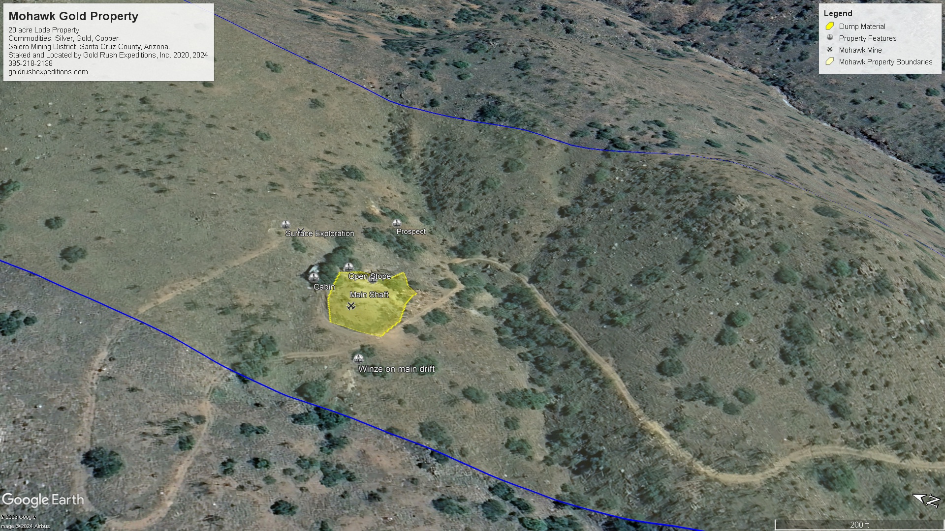
The Mohawk is a 20 acre lot covering a series of large and productive mines that date back to the early 1800s. Initial workings in the region were credited to Jesuit priests. The land opened up for American Miners after the Gadsden Purchase in 1854.
The Mohawk sits roughly 1 mile south-east of the original Salero Mine. Surveys and mapping put the subsurface workings at just over 3000' of drifts off the main shaft.
Assays from the Department of the Interior range give copper values at 2.3% average and 0.3 oz/T in AU. Surveyor assays from 2016 reported an average assay of 0.65 oz/T AU and 4% copper. The material in the dumps was the source of the assay material. There are roughly 30,000 tons of material that has been exacavated and dumped from the subsurface workings. Visible gold in the dump material was noted.
There is what is assumed to be an extension of the Mohawk with several covered shafts and footings for headframes and steam engines.
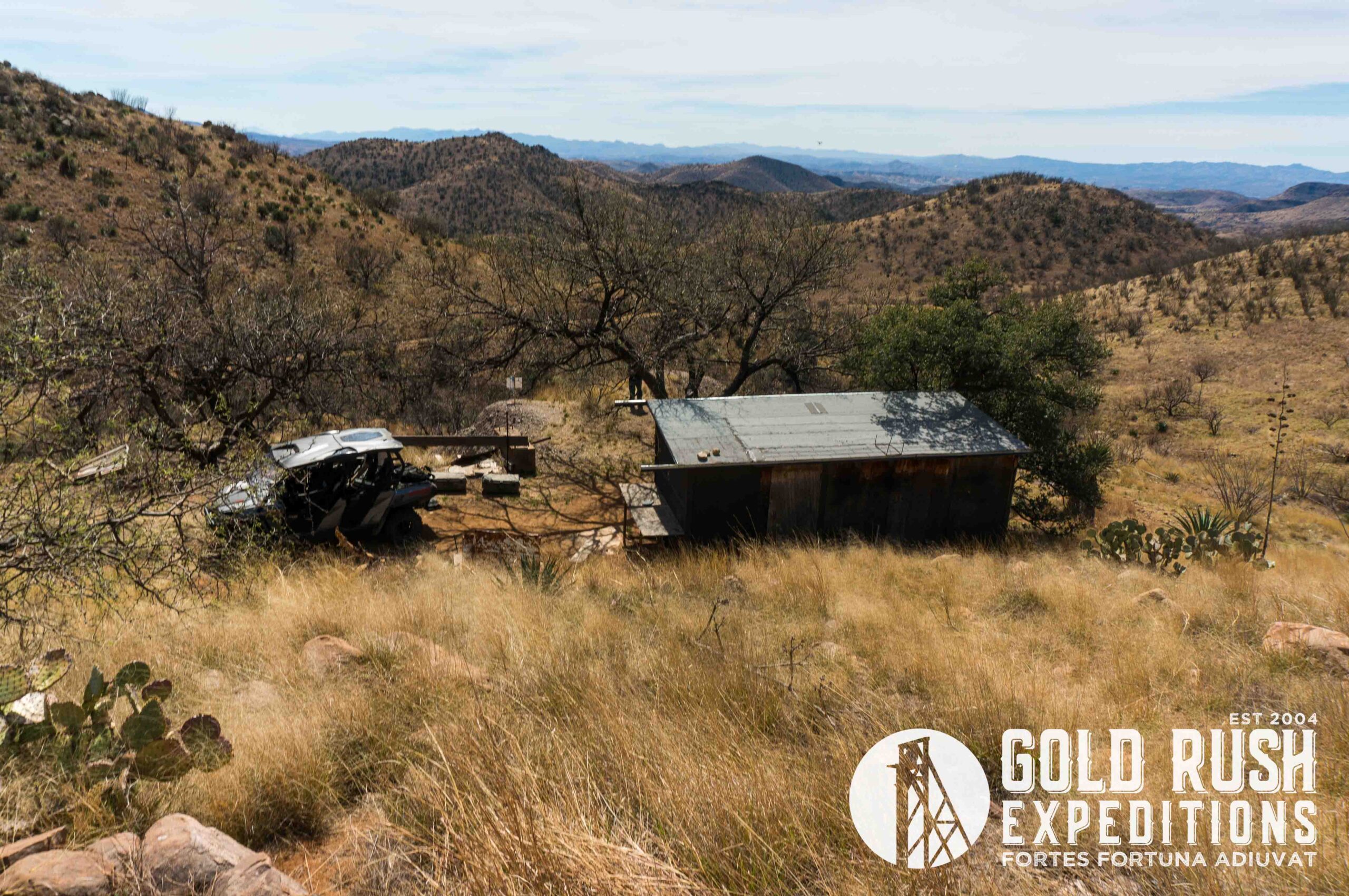
There is a well maintained cabin on the property that can be utilized within usual public land rights. This was the mine camp as well as there is a crude smelter and several flats for crushing ores.
According to historical documentation: "The Mohawk claim was located during the 1870's, long before the Southern Pacific railroad was built from Tucson to Nogales and even prior to the completion of the rail line from Tucson to Benson, thence El Paso and other eastern points. In fact the Helvitia mineral belt was prospected by the Spanish and Indians under the Padres, located in the old town of Tubac, built on the west bank of the Santa Cruz river, as headquarters, from whence the search for silver and gold was carried into the surrounding mountains and canyons, as far back as the 16th century. Small, adobe smelting furnaces, fired with iron wood (Palo Fierro) or charcoal, provided the metallurgy for the rich copper carbonate ores, with silver and gold as part of the ore content. The remnants of these first smelters are still evident. "
More recently, an overview of the ores and material at the property by the USBM. 1943 - "Some of the largest and most valuable mineral showings followed the acquirement of the properties by the Lewishons. The Mohawk was amongst these and the following developments and stoping of ores was pursued for a period of six or seven years. A copper carbonate and oxide cropping, fully 40' wide, forming the south east bank of a dry wash, which outs through this mineral body from east to southwest. This wash or flood water creek divides the surface continuity of the lode into two visible parts: That which is southeast of the wash, and the working and dump north of the creek. The bed of this dry wash is 40' to 60' wide and the sand and detritus floor from 10' to 20' deep. The southerly trend of the mineralization extends from the Southeast bank for about 500' and then enters the Northeast end line of the Old Dick mine of the Helvitia Company."
The mine was last held by a small group of miners who filed the claim in 1937 and held it until it was taken over by Gold Rush in 2015. James Marcum, according to the writing on the cabin wall, built the cabin in 1937 and held the property until his passing in 2012. His family maintained the property until 2015.
This is a remote location, north of the town of Patagonia, AZ.
The location is ideal for working without any disturbances. The surface ores could be worked very easily and show visible gold with silver. The rich material will be in the subsurface workings.
The site could be worked by one person, or a small group. It would not be ideal for a mining company at this level of development.
Gold Rush Expeditions, Inc. does offer mining consultation services and assistance with permits for a small fee.
Training courses for underground work and exploration can be found here: https://stayoutstayalive.com/training/
The Mohawk is a 20 acre lot covering a series of large and productive mines that date back to the early 1800s. Initial workings in the region were credited to Jesuit priests. The land opened up for American Miners after the Gadsden Purchase in 1854.
The Mohawk sits roughly 1 mile south-east of the original Salero Mine. Surveys and mapping put the subsurface workings at just over 3000' of drifts off the main shaft.
Assays from the Department of the Interior range give copper values at 2.3% average and 0.3 oz/T in AU. Surveyor assays from 2016 reported an average assay of 0.65 oz/T AU and 4% copper. The material in the dumps was the source of the assay material. There are roughly 30,000 tons of material that has been exacavated and dumped from the subsurface workings. Visible gold in the dump material was noted.
There is what is assumed to be an extension of the Mohawk with several covered shafts and footings for headframes and steam engines.
There is a well maintained cabin on the property that can be utilized within usual public land rights. This was the mine camp as well as there is a crude smelter and several flats for crushing ores.
According to historical documentation: "The Mohawk claim was located during the 1870's, long before the Southern Pacific railroad was built from Tucson to Nogales and even prior to the completion of the rail line from Tucson to Benson, thence El Paso and other eastern points. In fact the Helvitia mineral belt was prospected by the Spanish and Indians under the Padres, located in the old town of Tubac, built on the west bank of the Santa Cruz river, as headquarters, from whence the search for silver and gold was carried into the surrounding mountains and canyons, as far back as the 16th century. Small, adobe smelting furnaces, fired with iron wood (Palo Fierro) or charcoal, provided the metallurgy for the rich copper carbonate ores, with silver and gold as part of the ore content. The remnants of these first smelters are still evident. "
More recently, an overview of the ores and material at the property by the USBM. 1943 - "Some of the largest and most valuable mineral showings followed the acquirement of the properties by the Lewishons. The Mohawk was amongst these and the following developments and stoping of ores was pursued for a period of six or seven years. A copper carbonate and oxide cropping, fully 40' wide, forming the south east bank of a dry wash, which outs through this mineral body from east to southwest. This wash or flood water creek divides the surface continuity of the lode into two visible parts: That which is southeast of the wash, and the working and dump north of the creek. The bed of this dry wash is 40' to 60' wide and the sand and detritus floor from 10' to 20' deep. The southerly trend of the mineralization extends from the Southeast bank for about 500' and then enters the Northeast end line of the Old Dick mine of the Helvitia Company."
The mine was last held by a small group of miners who filed the claim in 1937 and held it until it was taken over by Gold Rush in 2015. James Marcum, according to the writing on the cabin wall, built the cabin in 1937 and held the property until his passing in 2012. His family maintained the property until 2015.
This is a remote location, north of the town of Patagonia, AZ.
The location is ideal for working without any disturbances. The surface ores could be worked very easily and show visible gold with silver. The rich material will be in the subsurface workings.
The site could be worked by one person, or a small group. It would not be ideal for a mining company at this level of development.
Gold Rush Expeditions, Inc. does offer mining consultation services and assistance with permits for a small fee.
Training courses for underground work and exploration can be found here: https://stayoutstayalive.com.training/
Acres
Commodities
Type
20
Gold, Silver, Copper, Lead, Zinc
Lode, Mill
Underground Dev
Surface Dump
Tailings
3,000 feet
30,000 tons
N/A
Access
Features
High Clearance 4WD
Cabin, workshop
Gold Reserves
Silver Reserves
Copper Reserves
Platinum Reserves
Tungsten Reserves
Molybdenum Reserves
Undefined
Undefined
Undefined
N/A
N/A
N/A
(385) 218-2138
or use our contact form below